 Eisey Lock & Rucks
Bridge Project
Eisey Lock & Rucks
Bridge Project


History
The History of Eisey Lock & Rucks Bridge
A Brief
History of the Cotswold Canal
Eisey (sometimes spelt Eysey) Lock is an un-shortened eastern T&S Canal lock designed to take Thames (Western) Barges of 90ft x 12ft approx with a draught of 4 ft. The lock had a fall of only 7ft rather than the more normal 9ft 4ins.
It seems likely that the brick walls were re-skinned at some point and there are some later patches. The surface brickwork has parted company from the wall behind in many places and sections have fallen off completely indicating that the repair work was not tied in sufficiently.
Both of the top paddle arches have partially collapsed at the face. The overflow weir appears to be in better a condition than most with the crest stones in place. The condition of the outflow culvert is unknown.
The bottom gates remain in situ but are very decayed above the water line and likely to collapse at any time. The paddle gear was rescued by the Trust in the mid 1970s and one set was restored to working order.
Just above the lock is the lock cottage which is very remote and now in a poor condition. It was abandoned in 1969 by the Laver-Priddy family.
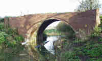
Like Eisey Lock, Rucks Bridge was built towards the end of the main construction phase of the Thames & Severn Canal, probably in 1788. It was probably originally built of rough stone with a brick arch and stone copings. The towpath wall at the bridge appears to have brick approach walls with stone copings but a dry stone wall with stone copings on the straight length under the bridge itself.
The offside (north) abutment between the waterline and the arch was rebuilt using T&SC stamped bricks and lime mortar perhaps about 40 years after the canal was opened.
A radical rebuild took place late in the canal's working life when most of the outer structure and a substantial part of the arch was rebuilt in red engineering brick using portland cement. This may have been in the 1895-1905 period when much restoration work was carried out along the whole length of the canal. Lengths of the coping stones were replaced with cast concrete.
Following the closure of the canal and prior to 1978, the parapets of Rucks Bridge have been demolished to allow wide farm vehicles to pass over the bridge unhindered. Much of the parapet brickwork and copings are in the canal under the bridge with the rest on the banks.
 |
A Brief History of
the Cotswold Canals
|
 |
The waterway between the rivers Thames and Severn consists of two canals which meet end on in Stroud. The first to open was the Stroudwater Canal which was build between 1775 and 1779 but was itself the third in a series of attempts to link the woolen mills of Stroud to the River Severn. It is a broad canal designed to take Severn Trow of up to 68ft in length and a beam of 15 ft. These craft could carry cargos of up to 100 tons. The Thames & Severn Canal was built between 1783 and 1789 and was a much greater engineering feat as it climbed to Sapperton Tunnel which pierced the Cotswold Scarp. The tunnel was the longest built at the time of construction but was also of one of the largest in cross section.
The completion of the T&S Canal provided the first inland waterway route between London and the Midlands but the poor state of the Thames navigation upstream of Oxford was to greatly limit the success of the through route.
The opening of the Kennet and Avon Canal captured most of the Bristol trade and the coming of the railways in the mid 1840s started a slow decline in trade from which the canals would never recover.
The summit level of the T&S Canal always required careful maintenance and water supplies from the River Churn in Cirencester needed to be supplemented by pumping at Thames Head using a beam engine. As trade declined in the late 19th century, the water levels on the summit were frequently allowed to drop to levels which caused navigation to become impossible.
The T&S Canal's plight became worse when control of the canal company fell into the hands of the Great Western Railway who, in the 1890s, sought to close the eastern part of the canal. A Trust was formed to restore the canal but this ran out of money and Gloucestershire County Council took over. The GCC did reopen the canal at the turn of the century but the levels of trade were insufficient to justify maintenance costs and the last boat traversed the whole canal in 1911. The canal east of Chalford was abandoned in 1927 and the rest in 1933.
The Stroudwater Navigation did not suffer the high maintenance costs of its younger brother and successfully captured a considerable amount of local trade, mainly supplying coal to the many mills in the Stroud Valley. However, commercial traffic ceased in W.W.II and the canal was formally closed in 1954 although The Company of Proprietors of the Stroudwater Navigation , its owners, continued to exist.
Both the T&S Canal and the Stroudwater Navigation are the subject of restoration proposals. The Cotswold Canals Trust has spear headed the campaign for 30 years and a recent breakthrough means that the project to fully restore these canals is being backed by the Cotswold Canals Pertnership, the Environment Agency and all the Local Authorities along the whole route and many other organisations. Various sections of the canal have been restored to full navigation including some of the flight of locks at Eastington and a decision to provide £12m of Heritage Lottery Grant coupled with matched contributions from other sources will see the restoration of 6 additional miles of canal between Stonehouse and Brimscombe Port in the near future.
Home | Location | History | Technical | Pictures | Background Information | Contacts | Links
This document is maintained by ken.burgin@pikelock.com .
Copyright © 2004 Cotswold Canals Trust; all other rights reserved