The Current Situation
Map
The Stroudwater Canal leaves Saul Junction on the Gloucester and
Sharpness Canal and heads eastwards to Whitminster Lock which is
undergoing restoration by the Cotswold Canals Trust. This lock has
conventional mitred gates at its
head but will have a guillotine gate at its tail in order to allow the
River
Frome to be drained down in the event of a pollution incident on the M5
or
A38. Whitminster Lock raises the canal about 10cm to the level of the
River
Frome. The integrity of the flood bank of the river is being maintained
by
building new flood banks which will interface with the bottom gate of
the
lock prior to connection of the lock to the river channel.
Original plans of the Stroudwater Canal show the canal and river
sharing the same channel for a length of about 600m before diverging.
However, at
some point it was decided to run the canal in a parallel channel to the
south
of the river with an aqueduct crossing (Lockham Aqueduct) to take the
canal
over to the north side. Since the canal and river levels were the same,
the
river ran under the canal in a deep sump and this lead to its removal
following
the abandonment of navigation as a flood prevention measure. The canal
and
river channels were subsequently merged into the current configuration.
All of the proposed routes use the combined channel from Whitminster
Lock
to the site of Lockham Aqueduct.
The 1779 Stroudwater Canal Route
Map
The 1779 canal is now cut off from the river at the site of Lockham
Aqueduct by a high flood bank and follows its route eastwards via
Stonepitts Bridge (culverted) and Occupation Bridge (restored). Pictures
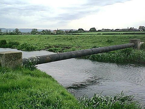
It is crossed at low level by an MOD fuel pipeline just west of
Occupation Bridge and this pipeline also crosses the River Frome at low
level.
The 1779 canal channel is in water and intact as far as the A38
roundabout. Bristol Road Lock (8ft 9ins rise) and the whole canal
eastwards from this point was obliterated for almost a mile at the time
of the building of the
M5. The original course is obstructed by the A38/A419 roundabout, part
of
the A419, the M5 and its Junction 13 southern slip roads. All of the
canal
land not covered by roads was filled in and given to the landowners
affected
by the construction of the M5 as part of their compensation package.
Picture
There is a 3m wide by 2m high concrete cattle crossing under the M5
close
to the route of the 1779 canal. It is used to link farm land on either
side
of the motorway. Pictures
 Remnants of the 1779 canal appear again at the restored Westfield
Bridge
(which was saved by its then owner from the M5 demolition men) and
Westfield
Lock which was partially blown up and infilled without permission. All
of
the route options converge at or near Westfield Bridge and the section
of
canal beyond is in water and being restored or is already restored and
in
use.
Remnants of the 1779 canal appear again at the restored Westfield
Bridge
(which was saved by its then owner from the M5 demolition men) and
Westfield
Lock which was partially blown up and infilled without permission. All
of
the route options converge at or near Westfield Bridge and the section
of
canal beyond is in water and being restored or is already restored and
in
use.
The River Frome
Map
The River Frome continues upstream from the site of Lockham Aqueduct
and
passes under a small low level farm bridge. This length of river was
made
navigable in the 1740s by Richard Owen Cambridge and was then used, and
possibly
further improved, by John Kemmett for his navigation in around 1760.
Between the farm bridge and Fromebridge Mill, the river is crossed
by a
MOD fuel pipeline at a low level. Picture
Until recently, Fromebridge Mill was operational and still derived
its power from water. This placed considerable constraints on the
potential use
of the river for navigation and for any proposed flood relief works
upstream.
Pictures
Fromebridge Mill is now a public house and restaurant and the
presence of boats would be a positive benefit to its owners.
At Fromebridge Mill the river passes over a weir with a fall of
about 1.5m-2m.
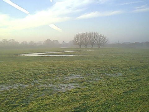
The operating level of the river upstream of this weir is very high in
comparison
to the surrounding fields and is frequently only constrained by its
flood
banks.
A little upstream of Fromebridge Mill, the river is crossed by the
A38 on two bridges with limited headroom and then a little further on
by the M5
with a headroom of about 1.5m. In between the A38 and the M5, the river
is
wide and is crossed by major gas and water pipes below its bed level.
Vestiges
of the original pre 1760 meandering course of the River Frome can be
seen
in the fields adjacent to the current course of the river.
Picture
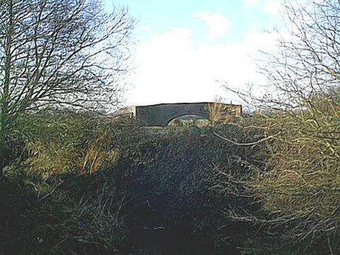
The M5 river bridge has a very wide crossection for flood capacity
reasons but has a limited headroom of about 1.5m (5ft) over the current
river level. The river channel under the bridge is heavily silted on
both sides.
Pictures
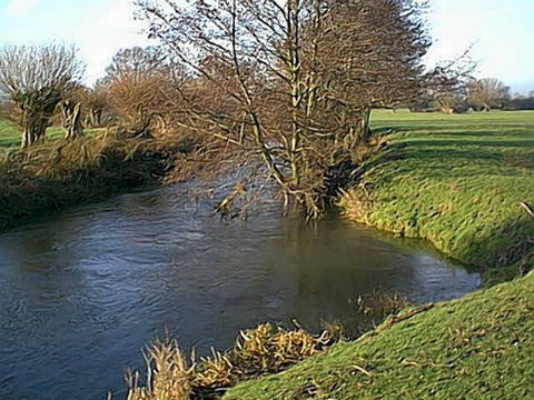
To the east of the M5 the river takes a fairly sharp bend to the
south and becomes narrower. Picture It
continues with a number of bends to its confluence with Oldbury Brook
just to the west of Meadow Mill. The whole length of river between the
A38
and Meadow Mill once formed part of the Kemmett Canal.
Oldbury Brook used to flow across the Stroudwater Canal above
Whitminster Lock on the level and its out fall from the canal was at
the large Meadow Mill overspill weir. Following the building of the
Motorway and the development of the Industrial site at Meadow Mill,
Oldbury Brook has been lowered through the bed of the canal and follows
a new course to the west of its original.
contents