Wildlife and Mitigating Measures
The river route, in common with the other options, joins the River Frome just above Whitminster Lock. Pictures The aim is to produce a scheme which is as simple as possible and which takes into account a wide range of interests.
At the site of Lockham Aqueduct, the route would continue along the river along the 1740 navigation towards Fromebridge Mill rather than following the 1779 route.
The first obstruction is a small farm access bridge which spans the river close to the site of Lockham Aqueduct. This will need to be raised by about 1.8m to create 2.4m of headroom above the highest river level likely to be encountered under navigable conditions.
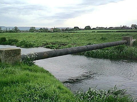
The next obstruction is an MOD fuel pipeline which crosses the river at low level. Picture This will need to be dropped below the river level as it is understood that the MOD will not allow it to be raised over the navigation. This pipeline is shut down for maintenance every 2 to 3 years and the works would need to be timed to coincide with this.
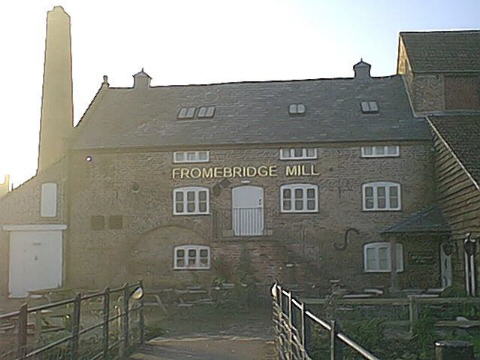
The river between Whitminster Lock and Fromebridge Mill has been used as a navigation before and only limited straightening works and dredging are likely to be needed. Flow rates after wet weather may be an issue, especially at Fromebridge Mill, and some widening and deepening may be required in places. It is not anticipated that navigation will be permitted in flood conditions. At Fromebridge Mill, the small bridge between the car park and the mill building would need to be raised to provide headroom. It is likely that visitor mooring would need to be provided close to the mill. Picture
The main works to the river itself would be required in the length between Fromebridge Mill and a point east of the M5. The proposal is to remove the weir at Fromebridge Mill and lower the river level by about 2m for a distance of about 1km in order to create sufficient headroom under the existing A38 and M5 bridges. This will involve the excavation of about 25000 cubic metres of material from the river bed which presumably will have to be removed from the flood plain.
The existing A38 bridges (picture) would not need to be raised but work is expected to be required underneath the bridges to ensure the lowered channel does not compromise their supporting abutments. This means that the existing services, including the BT fibre optic cable (claimed to cost £250,000 to move!), will not need to be disturbed. Similar work will be needed under the M5 but the additional width available should make the work easier in this case. A detailed study of this option has been made by Halcrow and a report issued early in 2000.
Major gas and water pipelines which run north-south between the A38 and M5 will need to be lowered from their existing levels below the current river bed.
Just east of the M5 crossing, the river makes a sharp bend to the south and it is at this point that the navigation would leave the river and pass through a single lock with a rise of about 2.4m (8ft) which would raise the navigation to a suitable level to cross to Westfield Lock. A replacement weir for the one removed at Fromebridge would be located in the river close to the new lock. This could take the form of a slope or a series of small steps rather than a single vertical drop.
In order to require just one lock, the banks of the new length of canal may need to be raised slightly above the existing ground level, however, any effect on the overall flood plain would be more than offset by the removal of the 25000 cubic metres already identified and a substantial improvement in the drainage capacity of the river itself.
The new canal channel will leave the new lock and run in parallel to the River Frome and Oldbury Brook. If the land take is to be minimised, the new length of canal will need to approach the original 1779 canal route at Westfield Bridge at an angle of about 110 degrees and a reasonably large turning pool will be required.
Westfield Lock would be restored and would raise the canal approximately 10ft with 1.5m of water over the lower cill. Oldbury Brook would pass under the canal under a new aqueduct on the upper approach to Westfield Lock as this arrangement is considered more satisfactory than the original level crossing with its limited flood control capability and susceptibility to silting.
The existing water levels in the River Frome downstream of Fromebridge Mill are constrained by the level required to feed the Gloucester and Sharpness Canal. The level to the east of Fromebridge Mill has been governed by the recent use of water power at the mill. In both areas, the Frome is at an artificially high level with respect to the adjacent land and parallel watercourses running at significantly lower levels are used to drain the land.
The proposed navigation works would not significantly affect the river levels downstream of Fromebridge.
The proposed navigation works upstream of Fromebridge would drop the river level from approximately ground level to about 2m below it. This will improve the drainage of the adjacent land and is made possible by the conversion of Fromebridge Mill into a pub/restaurant.
The option exists to design the works to maintain the existing flood characteristics of the flood plain or to reduce the flooding which takes place fairly frequently in some areas. The new deeper channel is most unlikely to overtop its banks if they were at ground level but raised flood banks might be required to allow the flood plain to hold water and to prevent the water from being dissipated downstream too quickly.
Wildlife and Mitigating Measures
Various sources of information exist on the flora and fauna on both the River Frome and the Stroudwater Canal. The following is not intended to be a definitive statement on the subject and additional input from experts will be required in due course.
The river route above the site of Lockham Aqueduct uses a significant length of the River Frome which, for the whole length involved, passes through agricultural land.
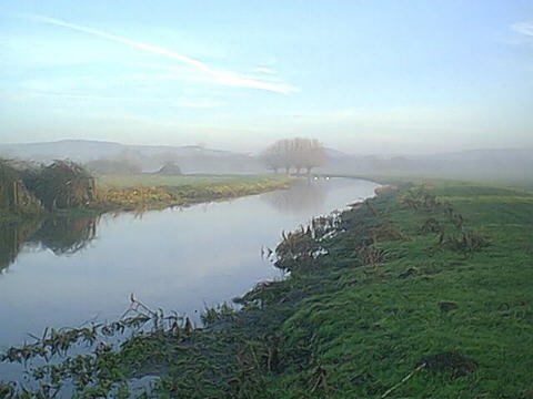
The character of the existing river is one of a fairly wide and deep channel of slow moving water with emergent vegetation on the edge of the river on the inside of the flood banks. Picture There are a small number of trees along the banks, mainly pollarded willows.
The changes to the river downstream of Fromebridge Mill are likely to be minimal.
The river upstream of Fromebridge Mill would be dropped by about 2m but would remain a deep slow moving watercourse. The new banks would be similar in nature to those found in other places further upstream where the river level has been dropped following the cessation of milling operations.
The proposed location of the new lock together with its weir, and divergence of the navigation from the river just east of the M5 leaves the meandering and shallower sections of the river upstream of this point as they are.
The principle bonus in wildlife terms of using the river route is that it bypasses the length of the Stroudwater Canal (1779) between the site of Lockham Aqueduct and the A38. This section of canal offers a different and perhaps more valuable wildlife habitat than the river itself. It is less susceptible to rapid fluctuations in water level and dense mature vegetation reaches down to the non-towpath bank in places.
The execution of the engineering works will inevitably lead to some disturbance but careful planning and timing can be used to minimise this. The actual nature of the activity is probably not a lot worse than the regular dredging that already takes place from time to time.
Once complete, the passage of boats is not expected to have a major impact. Comparison with the wildlife on established small river navigations of a similar nature is expected to show that wildlife successfully co-exists with the anticipated levels of boating activity. Suggested comparable waterways
The navigation of the river route should not present particular difficulties to boaters except in times of high flow in the river. Fortunately, such times tend to occur in the winter when boating activity is at its minimum. Even so, there is often a significant current in the river.
Without the rebuilding of Lockham Aqueduct, which is assumed to be unacceptable for flood prevention reasons, boating activity would be affected by adverse river conditions on all the potential restoration routes.
Another issue affecting navigation is one of silting. Rivers carry more silt than canals and this tends to settle on the bottom in areas of reduced flow. Dredging takes place over these parts of the river already in most years - it is not obvious that making the river navigable would significantly change the existing burden of maintenance.
The lack of a hard edge will tend to discourage mooring on the river sections which is probably just as well. However, demand will exist for moorings at Fromebridge Mill and facilities for this (with suitable notices about changes in river level) should be provided.
The new lock east of the M5 has a rise of about 2.4m which is comparable to many of the locks elsewhere on the Stroudwater Canal and is therefore unexceptional.
The tight bend at Westfield Bridge where the new channel meets the 1779 route is tight but not unprecedented. With suitable rubber buffering on any hard edges, it will be regarded as a challenge rather than a hazard.
Procedures need to be developed for either indicating when navigation should not take place (coloured level indicators as per the Calder and Hebble Navigation) or to physically close the navigation in times of flood or high flow.
In particular, careful consideration needs to be given to the procedure for dropping the river level in the event of a pollution incident on the M5 or A38. The river level needs to drop about 10cm to below that of the Gloucester and Sharpness Canal but the sudden complete emptying of the river would leave any boat visiting Fromebridge Mill, or in transit, high and dry. This problem is not unique to the river route.
The main advantage of the river route is its simplicity and lack of new road bridge construction both at the A38 and the M5.
The need to exit the significant flood protection banks at the site of Lockham Aqueduct to re-enter the 1779 Canal is eliminated.
There is an opportunity to improve the flood plain and land drainage management upstream of Fromebridge Mill.
The local economy will benefit from additional waterborne visitors to Fromebridge Mill.
There is a high probability that only 1 new lock would have to be built.
The surviving length of the 1779 Canal west of the A38 is potentially more valuable to wildlife than the length of the river proposed for use as an alternative navigation.
The main disadvantages are:
The relocation of the weir which would adversely
affect
the context of Fromebridge Mill
Uncertainty as to what needs to be done to the footings of the existing A38 bridges
Concerns, whether reasonable or not, regarding the habitats along the river.
Flow rates in the river adversely affecting navigation
Much of the river would be between high banks
upstream
of Fromebrigde Mill